
|
|
|
|
Ads by Infohub
Partnership with TGCT
Mutual Support with JCA |
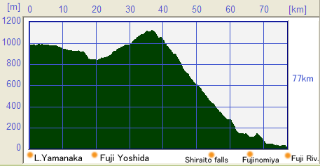
Length of Japan : TokaidoAroud Mt.Fuji : Yamanaka Lake-Fuji river estuary (77km)Map of this routeSummary
Profile map
Detailcycling on the east-side of Mt.FujiThe starting point of this section of the JCN route is Lake Yaksmanaka(山中湖) which is one of the well known Five Fuji Lakes(富士五湖). Following National Route 138, the JCN route goes along the shore of Lake Yamanaka in a clockwise direction. You will meet an intersection with National Route 729, you should follow Route 729 along the lakeshore for approx 500m, where you will come to a T-junction with a small bridge. You need to turn left at this junction and you will be able to see a bicycle track on the other side of road which you should follow.  This bicycle track leads to “Hanano-Miyako (Flower) park(花の都公園)” which provides a wonderful open view and looking back, there will be a marvelous sight of Mt. Fuji. Keep going forward to north in the park, and you will go through shrubbery, after that you need to turn left. The JCN route then goes through peaceful country side until reaching Oshino Hakkai(忍野八海)” that is famous for natural springs which flow from Mt. Fuji and for preserved traditional houses. cycling on the north-side of Mt.FujiFrom “Oshino-Hakkai” the route is back to a National Route, National Route 138. Frequent traffic jams and narrow, congested roads are normal for National Route 138. There are number of less attractive places in this particular section and you may be required to be patient for a while. Once past Michinoeki (road-side station) Fuji Yoshida(道の駅富士吉田), the Route becomes double lanes, which provides a slightly more comfortable ride but there is still few places worth to see on this part of the route. After passing the entry ramp Inter change (Kawaguti ko(河口湖) IC) for the express highway, the route gradually ascends the slopes of the northern side of Mt. Fuji. Here there are the popular sight seeing area of the Fuji Five Lake which consists of Lake Yamanaka, Lake Kawaguchi(河口湖), Lake Sai(西湖), Lake Shyojin(精進湖) and Lake Motosu(本栖湖). The Lakes are however, located a slight distance from National Route 139. If you are interested in seeing these lakes, the shore of each lake shore is flat and worth spending time to visit. Particularly, enjoyable is seeing the magnificent Mt. Fuji scenery reflected in the surface of the lakes like a mirror. Nearby on National Route 139 is “Kouyoudai(紅葉台)” a famous spot to enjoy clear views of Mt. Fuji. After passing Michinoeki (road side station) Narusawa(道の駅なるさわ) and climbing up to the top of the slope, there is a small T-junction, which is an entry to “Kouyoudai”  Turn right at this T-junction and go ahead for a while to where there is a parking area and a shopping store. People who come here by car leave their vehicles here and start their trek up to the Observatory, which is about 30 minutes of walking. Bicycles are also able to be ridden up to the Observatory but the track from the shopping store is unpaved and steep. You must also need to pay attention to hikers walking along the road. cycling on the west-side of Mt.FujiThe route chosen in this guidance (the JCN) turns left at where Route 71 and National Route 139 cross, just before the turn of to “Koyoudai”. The road Route 71 is selected for the JCN rather than National Route 139 due to its lower traffic levels. In addition you are able to see Mt. Fuji from much closer.  Continuing on, the JCN route keeps gradually ascending the slope. When you reach the top of the slope, the long descent to Fujinomiya city(富士宮市) begins. As you descend down hill the iconic beauty of Japan, Mt. Fuji, will be showcased. In the middle of the descent you come to a T-junction; turn left and keep going on R71. Soon after crossing the National Route 139, you will see a junction with a convenience store “Family mart(ファミリーマート)” and a prominent pine tree as a landmark.  Main JCN path continues straight through this junction and turns right at the road sign for R75. The path becomes moderate steep and heads in a southerly direction. In this part of the route there is dramatically less traffic and you should get some peaceful riding. The JCN route goes left at the intersection with R184 which leads you along R184 to downtown Fujinomiya city. In the middle of this section, the route takes a winding road among forest and then enters the narrow downtown streets, so that, you are able to experience several different local sceneries. The route goes always straight so there is little reason to be worried about getting lost. Part of the way there is a one-way traffic zone, but bicycles are able to keep going straight, until meeting the shopping streets in down town of Fujinomiya.  Heading East along the shopping street with arcade, approx 1km distance, should lead you to Fuji Sengen shrine(浅間大社). This shrine to volcanoes has a number of other locations including one on top of Mt. Fuji where there is a natural spring recognized as one of the hundred great natural springs in Japan. You should keep an empty bottle, to be filled with water from this natural spring. From the main temple of this shrine, Mt. Fuji can be seen clearly. Road to the Pacific OceanAfter looking at Fuji Sengen shrine, the JCN route leads you up to the point that Fuji river meets the Pacific Ocean,.  After crossing the bridge across the Fuji river(富士川), you should turn left to R10. This R10 is adequately wide, and you may see Mt. Fuji behind the Fuji river on your left. Passing under the highway twice, you will reach the Fuji-gawa (river) bridge that will take you to Old-Toukaido. The combined view of Mt. Fuji and the Fuji river from this place, makes it one of the best place to experience the beauty of Mt. Fuji.
uploaded:07, 04, 2019 |

|
|
|
Copyright "Japan Cycling Navigator". All
rights reserved.
|
