Length of Japan:Hokkaido
3.Sapporo to Asahikawa
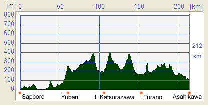
Map of this Route
Summary
| Route : | Sapporo(札幌) Yubari(夕張)Furano(富良野)Asahikawa(旭川) Yubari(夕張)Furano(富良野)Asahikawa(旭川) |
| Distance : | 212 km (132miles) |
| Best Season : | July to August |
| Available Season : | April to Middle of November (Possible snow in April and November)
|
| Steepness/terrain : |
 (Although the bike route goes through a mountain area, (Although the bike route goes through a mountain area,
up and down gradients are moderate.)
|
| Natural Beauty : |
 Abundance Abundance |
| History : |
 (Coal Mining Monument in Yubari) (Coal Mining Monument in Yubari) |
| Traffic : |
 (Less than normal traffic through out the route) (Less than normal traffic through out the route) |
Profile Map
Detail
Shiroishi Cycling Road
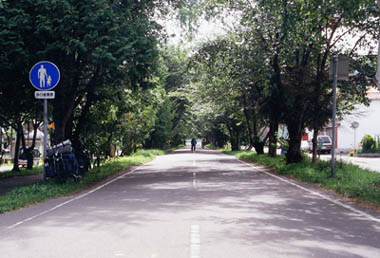 To find the Shiroishi Cycling Road, head for the Higashi-Sapporo subway station as the street signs in other parts of the City may not be clear enough. When you will arrive at Higashi-Sapporo station, take to the right (Southwest) to get onto the Shiroishi Cycling Road. To find the Shiroishi Cycling Road, head for the Higashi-Sapporo subway station as the street signs in other parts of the City may not be clear enough. When you will arrive at Higashi-Sapporo station, take to the right (Southwest) to get onto the Shiroishi Cycling Road.
The Shiroishi Cycling Road takes you to Kitahiroshima and runs along the old railway tracks just like many other special cycling roads in Japan. The beauty of this cycling road is that most of the intersections with vehicular roads have an overpass or an underpass and you can continue to ride without interruption. As the intersections are either bridges or tunnels, even cyclists from Europe are impressed with the quality of the facilites. We can say that the Shiroishi Cycling Road is the ideal bicycle road for an urban area.
The first city reached on the road is Yubari which is riding east from Kitahiroshima(北広島). There may be a lot of vacation traffic on this route especially at weekends. Be careful!
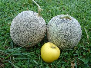
Symbol of Hokkaido
 The city of Yubari(夕張) was famous for coal mining. However, the mine operations closed in 70s and 80s and so Yubari re-invented itself as a tourist centre.
The Coal Mining Museum was established with considerable contributions from public funds and is a conversion of an old coal complex. At first the Museum seemed to be successful in attracting tourists including family groups.
It now seems that this was at some cost and the budget deficits of Yubari city has meant that the city is officially in financial reconstruction.
Apart form the mining museum, the city is famous for the Yubari Film festival which attracts many of movie enthusiasts.
Also, the Yubari Melon from this region is regarded as the top melon brand among Japanese consumers and has become an iconic symbol of Hokkaido.
Into the woods
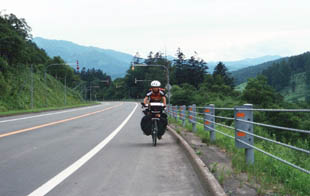 If you ride toward south out of Yubari on Prefecture Road #38, you will enter Shimizusawa(清水沢). When you take National Route #452 at Shimizusawa, our "Length of Japan" route goes into the mountains and there will be no shop for another 100 km!!
This section is one of the most remarkable on Hokkaido as you can feel the scale of the land and all you see is nothing but nature. Make sure to carry enough water and food for the 100 km ride between shops.
The area called Kashima(鹿島), 15 km from Shimizusawa,also had coal mining operations with at population of about 20,000. Since the coal complex shut down, the population of Kashima has fallen dramatically. What is more, much of the Kashima area will eventually be underwater when the Yubari Shuparo Dam is completed in 2013.
Furano
 Furano city(富良野市) is always busy with many tourists since this city was featured in the well known TV series "Kitanokunikara (1981 to 2002)".
Kitanokunikara means “From the northern home". It is a human drama about a father and his children who returned from Tokyo to Furano. It showed how they lived and adjusted to a different life, overcoming many difficulties in the rural environment of Hokkaido. Even after completion of first-run broadcasting, Kitanokunikara has remained very popular among Japanese of all generations. The 21 year broadcasting history of Kitanokunikara followed the real growth of the characters and the performers, especially the son, his sister and friends. This year by year development of the characters made for compulsive viewing and was a major factor in its attraction for the TV viewers.
Furano was the main location of the Kitanokunikara story and continues to attract many tourists.
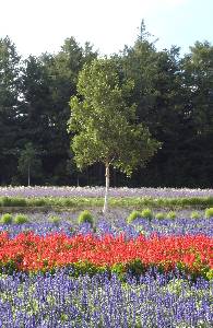
Furano is also famous for its lavender gardens and farms. If you want to see lavender, visit Saika-no-sato(彩香の里) in Hokuseiyama(北星山), west of Naka-Furano. Although the Farm Tomita is very famous for lavender, we think most people will find Saika-no-sato more impressive. In the Hokuseiyama area, there is a camp site, Sinrin-koen Camp site(森林公園キャンプ場) which should give you an enjoyable say.
Biei
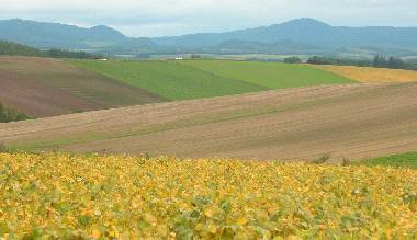 The scenery of the area from Kami-Furano(上富良野) to Biei(美瑛) is very beautiful. You will enjoy the dramatic farming landscape and you can just crank-away as you like without having to check the map.
There is a famous photo gallery, Takushinkan(拓真館) of Shinzou Maeda(前田真三) in Biei. Also there are many craft centers and shops selling natural products which will add to the enjoyment of your visit.
You will also enjoy the town-space of Biei because unlike other cities in Japan, all the power lines are laid underground.
A tip for photographers in Biei is to climb up to the highest point in the
district where you can find some narrow local roads on the hillside, which
will avoid using the National Road. For example, so called the "Roller
Coaster Road (Jet Coaster Road)"(ジェットコースターの道) is highly recommended.
When you get up to the hill called "Patch Work Hill"(パッチワークの丘), you will have many great photo opportunities and Asahikawa, the second largest city in Hokkaido, is nearby. Take a side road off the hill and ride carefully (cars!) down to Asahikawa.
Not to be missed!!
Traverse Daisetsuzan
 While riding from Furano to Asahikawa, you will see the Daisetsuzan(大雪山) on your right (East). You may be interested in climbing up Daisetsuzan and it is so huge, you will not appreciate the landscape of this mountain by bike. It will take 5 days to ride through the Daisetsuzan district from south to north. There are no lodges to stay in. Only basic unattended shelters. In Tokachidake(十勝岳), part of Daisetsuzan, the unattended shelter has collapsed and not been repaired since Jun. 2006.
You need to be clothed for trekking (good boots!); carry a map, compass and emergency food and water and make appropriate time and route planning
However, Daisetsuzan can be scaled by cable car at Asahidake-onsen from
the east (or at Souunkyou canyon from the west).
Remember, make sure to carry warm clothing, food, compass and map.
Banei Keiba(Draft horse races)
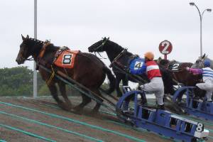 Banei is a breed of horse, developed in Japan. It is used in horse racing, and pulling heavy sleds in Banei Keiba races(ばんえい競馬). The breed comes originally from Percheron and Breton horses. (Quoted from Wikipedia)
The horse culture in Hokkaido is world famous because of the Banei Keiba races and their associated activities. The origins of the races come from the use of the powerful, rugged draft horses during the pioneering phase when this region was being opened up. In the races, the horses pull a sled weighing about 1 ton and the course climbs two artificial hills. The pace of the race is quite slow and this means you can see and enjoy the whole race in its entirety.
The course is on soft sandy ground and this, together with the artificial mounds and heavy sled, make it very arduous for the horses. This means that the jockey must be very skilful in giving his/her horse short rests so as not to overstretch its ability, especially on the approach to the mound. The way in which the jockeys control the stopping and starting of the horses is one thing that spectators especially appreciate”
Banei Keiba races have been held in Iwamizawa, Asahikawa, Obihiro and Kitami. However, it has not always been profitable and a financial reorganization was needed in early 2007 when Softbank, a famous IT company, stepped in to back the Banei Keiba. Since then the Banei Keiba has been held only in Obihiro(帯広).
 Banei Keiba(draft horse races)[E][F] Banei Keiba(draft horse races)[E][F]
It's a shame that "Banei Keiba" has been suspended in Asahikawa and the other 2 places so that Obihiro is only one place you can see it. This means you should be sure to check the schedule in advance.
Route
Route summary
| Sapporo(札幌) [20m]
|

 | Shiroishi Cycling Road (Bike path) (白石サイクリングロード)(21km)
|
| Kitahiroshima(北広島) [23m] |
 | Prefecture road #3(39km) |
| Yubari(夕張) [260m] |
 |
Prefecture road #38 (6km)
National route #452 (39km) Pass [420m] |
| Katsurazawa Lake(桂沢湖)[220m] |
|
National Route #350 (23 km) Pass [430 m]
Prefectural Road #135 (18 km) Pass [370 m]
National Route #38 (5 km)
|
| Furano(富良野) [170m] |
| (21km)
|
| Biei(美瑛) [236m] |
| (40km)
|
| Asahikawa(旭川) [113m] |
(Red: National Route, Green: Prefecture Road, Yellow green: cycle path, gray: other roads)
Web Forum
You can disccus about cycling in Japan in Japan Cycling Navigator Facebook group 
Back to (Kuromatsunai ---> Sapporo) (Sapporo ---> Asahikawa) Forward to (Asahikawa ---> Wakkanai)
uploaded:14, 04, 2019
|