
|
|
|
|
Ads by Infohub
Partnership with TGCT
Mutual Support with JCA |
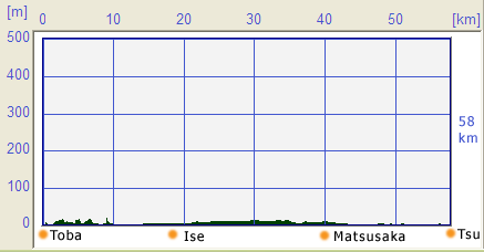
Length of Japan : TokaidoToba to Tsu 52 kmMap of this routeSummary
Profile map
DetailToba famous as sea otter breedingThe Length of Japan (LOJ) Tour, connecting from Toba in Mie Prefecture to Kyoto, starts at the Isewan Ferry terminal in Toba.  Ferry is to discontinue service to cross Ise Bay at the end of September 2010. see below The first section of the LOJ is the route connecting Toba-city, Ise-city, Matsusaka-city and Tsu-city in Mie prefecture.  The Isewan Ferry is located next to the Toba aquarium, which is famous for sea otter breeding.  Ride north on National Route #42 which runs north to south in front of the ferry terminal (and aquarium). You will reach the intersection as shown in the photo. Turn right here to Futaminoura (二見浦) famous for “Meoto-iwa” (夫婦岩). The toll road straight ahead is for cars only. Meoto Iwa (夫婦岩)Riding on the National Route #42, you will see the Futami Sea Paradise (二見シーパラダイス) , an aquarium for younger children, on your right. After the Futami Sea Paradise (二見シーパラダイス), you will find a narrow street which heads toward the coastline. The “Meoto Iwa (Husband-and-Wife Rocks”(夫婦岩) is on the coastline.  Meoto Iwa (夫婦岩) or the Husband-and-Wife Rocks are a couple of small rocky stacks in the sea of Futami, Mie. They are joined by a shimenawa (a heavy rope of rice straw) and are considered sacred by worshippers at the neighboring Okitama-jinja. In Shinto belief, the rocks represent the union of creator gods Izanagi and Izanami. The rocks therefore celebrate the union in marriage of man and woman. The rope, which weighs over a ton, must be replaced several times a year in a special ceremony. The larger rock, said to be male, has a small torii at its peak. The best time to see the rocks is at dawn during the summer, when the sun appears to rise between them. Mount Fuji is distantly visible. At low tide the rocks are not separated by water.
For more information visit Visit one of the most famous Shrines : Ise JinguAfter visiting Meoto Iwa (夫婦岩), you can take same street to National Route #42. Also, you can go through the Ryokan (Japanese Hotel) area to enjoy the atmosphere of a traditional hotel. You can return National Route #42 at any time by taking one of the streets on your left.  Following National Route #42, this route crosses with the overpass of National Route #23. National Route #42 then changes to Prefecture Road #102. Go straight on Prefecture Road #102 and you will enter the intersection. Go right on Prefecture Road #37. Your next landmark is then JR Iseshi station (伊勢市駅). In Ise-city, we recommend to visit Naiku and Geku of Ise Jingu (Jingu). Ise Jingu (Jingu) 伊勢神宮
Ancient road Ise-KaidoDid you enjoy the Jingu? Your next destination on the LOJ Tour is Matusaka-city (松阪市). Follow the Prefecture Road #37 in front of the JR Iseshi station (伊勢市駅) toward Matsusaka. The Prefecture Road #37 is a so-called bypass road that continues to Matsusaka. However, please note that there is very heavy traffic on the Prefecture Road #37. The National Route #23 will also bring you to Matsusaka, but this has heavy traffic too. In this LOJ Tour, we propose you take the traditional route called “Ise-kaido” (伊勢街道) which was used by the people who visited Ise-jingu (伊勢神宮) from Osaka, Nara and Kyoto at one time. This “Ise-kaido” (伊勢街道) can be slightly difficult to find, so please take the National Route #23 or Prefecture Road #37 to Matsusaka if you can not find the “Ise-kaido” (伊勢街道). The “Ise-kaido” (伊勢街道) runs between the Prefecture Road #37 and Kintetsu Railway line until Kushida-bridge (櫛田橋), so you will not get lost as long as you stay on the road/street in between Prefecture Road #37 and the Kintetsu railway line.  After riding about 2 km from the JR Iseshi station (伊勢市駅) on Prefecture Road #37, look for the sign JR Yamadakamiguchi station (山田上口駅) and ride toward this station. The road in front of the JR Yamadakamiguchi station is the Ise-kaido (伊勢街道), running parallel to the JR line. Iron railway bridge One of the good landmarks on Ise-kaido (伊勢街道) is Miyagawa-bridge (宮川橋) over the Miya-river (宮川). You will find a Railway iron bridge next to the Miyagawa-bridge (宮川橋). This iron railway bridge is quite famous among railway buffs.  The LOJ route from JR Yamadakamikuchi station (山田上口駅) to Miyagawa-bridge (宮川橋) is slightly complicated. Ride toward JR line (to the right) if you are confused. Go right at the spot shown in the photo (Photo in May. 2008).  You will find a sign Prefecture Road #428. The Ise-kaido (伊勢街道) is also called Prefecture road 428 around this area.  Soon you will enter the intersection Akeno (明野) with a traffic light which is easy to miss. You will see a sign stating 7 km to Matsusaka (松阪 7km). Follow this sign by turning left, and ride toward Matsusaka. Riding through the residential areaThe next landmark in this tour is Take-jinjya (竹神社) about 4 km from the intersection Akeno (明野). As the Ise-kaido (伊勢街道) runs through a residential area, there are no convenience stores or parks, so we suggest taking a break at the Take-jinjya (竹神社).  After your good rest, continue on Ise-kaido (伊勢街道). The course will meet the Kushida-river (櫛田川) . And Ise-kaido (伊勢街道) will merge into Prefecture Road #37. Go over the Kushida-bridge (櫛田橋) on the Prefecture Road #37. Slightly after the bridge, there is a narrow street to the left. Ride straight north in the direction of Matsusaka. The Ise-kaido (伊勢街道) will merge into Prefecture Road #756. But do not follow the Prefecture Road #756. Matsusaka famous for the beef cattleThere will be a railroad crossing about 3 km from the Kushida-bridge (櫛田橋). You will find JR Tokuwa station (徳和駅) beside the railroad crossing. You will find many different kinds of Night-lights which were used as guideposts of the Ise-kaido (伊勢街道) at one time. These Night-lights are good milestones for this section of the LOJ. When you see the Kobe-jinjya (神戸神社), you are almost at JR Matsusaka station (松阪駅), the center of Matsusaka-city. Matsusaka is famous for the beef cattle called “Matsusaka-beef” (松阪牛). Matsusaka is a type of Japanese Black Cattle that is raised around Matusaka in Mie prefecture. It is highly-prized as one of the top three types of Japanese beef, along with Kobe-beef and Ohmi-beef. In this area you will find some advertisement of restaurants like “Wadakin”(和田金), “Sanwa”(三和) and “Gyugin”(牛銀). If you are prepared to spend a lot of money for dinner, we expect you will enjoy the taste of the Matsusaka-beef. Lattice door houses The Length of Japan continues toward Tsu-city, which is the capital of Mie prefecture. Take the left hand street on the photo of Matsusaka station. You will find a convenience store about 2 km from Matsusaka station and it crosses with Prefecture Road #756. (Photo: May. 2008)  Turn right at the intersection of the convenience store on Prefecture Road #756. After you go over the railway line, take a street that forks to left. This street goes under the Prefecture Road #756. Turn left at the first intersection on Ise-kaido (伊勢街道). This part is slightly complicated. But if you get lost, go back on Prefecture Road #756 and take the National Route #42 which runs slightly east from here. The National Route #42 will take you to Tsu-city.  On the Ise-kaido, you will soon find a direction board showing the several old style houses in this area with lattice doors (Lattice Door House). You will enjoy the many different types of Lattice Door Houses: normal residences, shops and others.  Night-Light You will also see several Night-Lights between this area and Tsu-city, along with stone monuments as shown in these photos.   Riding through the Lattice Door Houses, you will find a stone monument on your right and a temple (三雲橋正院) on your left about 3 km from the direction board of Lattice Door Houses. Turn left at this intersection to continue the LOJ.  You will find more Night-Lights and stone monuments. The LOJ route will be difficult to follow after the Night-Lights in the photo. Again, if you get lost, use National Route #23 to Tsu-city. The LOJ route will go over the Kumozu-river (雲出川). The bridge on the LOJ course is located next to (west of) the bridge on the National Route #23. You will find larger Night-Lights in front of the bridge over the Kumozu-river (雲出川). There was a river ferry at one time before the bridge was built.   Turn left at the first traffic signal after the bridge, and you will cross over the JR line railroad. After crossing this railroad, turn right. The LOJ course will go under an overpass of National Route #165. Pedal along the route and the LOJ course will merge onto the National Route #23. You have just entered Tsu-city. Ride along the National Route #23 till the route crosses National Route #163. The LOJ course will take this National Route #165 to Igaueno (伊賀上野). about ferryIt is a shame that the ferry company announced that it plans to discontinue the line between Irago and Toba at the end of September 2010. A campaign collected 119 thousand signatures for a petition to continue the line according to the news reported on May 27, 2010. Ferry is working at least in 2019
uploaded:07, 04, 2019 |


 ISEWAN FERRY[J]
|
|
|
Copyright "Japan Cycling Navigator". All
rights reserved.
|
