
|
|
|
|
Ads by Infohub
Partnership with TGCT
Mutual Support with JCA |
Fukuoka - Tokyo : Attractive route with many attractions
Entrance to Japan (Fukuoka-Iwakuni)Summary
DetailEntrance to Japan "Fukuoka"Fukuoka is the gateway from Korea and the 4th largest urban area in Japan with a population of more than 2 million (the Big 3 is Tokyo, Osaka and Nagoya). If you want to start your ride from here you will have to ride through some ares of heavy traffic. The shortest route is Route #3 but we recommend taking another way at the 10 km point north from the center of Fukuoka city where there is a fork in the road. One branch continues as the R3 and the other is R495. R495 is a side road of the R3 which runs closer to the Japan Sea and is a more comfortable ride. Along R495 you can sometimes escape to the beache-side road. Those beaches are popular for bathing in summer and there is a pine-covered area along the road which is very typical picturesque Japanese scenery. After views of sea bathers and pine trees, you will see the huge iron-foundry plants on the waterfront which is Kitakyushu City. This where the first governmental iron foundry was constructed in the early Meiji ere which led to the development of an iron making region. In Kutakyushu city, Wakato tunnel and Wakato bidge are not allowed for cycling. You can find a ferry just 50-100m south of the bridge. You can bring your bike. It costs only 150 yen per person with a bike and is operated about 4 times an hour. Moji Port was the main port of the iron industry, and you can still see 18th century era plants and factories which are well preserved. Saying good bye to the waterfront iron and steel plants, you will reach to the northernmost tip of Kyushu Island. There are two ways to cross the Kanmon Channel to the main Honshu island of Japan. One is riding through the Kanmon "Channel Tunnel", which costs only 20 Yen and is 3 km in length. "Kanmon Kaikyo": straits with one of the most rapid tidal flows
Many historical (domestic) battles and skirmishes occurred here. The side which took good advantage of the rapid currents in the channel usually achieved victory. These rapid waterflows also provide us with wonderful gifts. The fish and seafood in the channel have to be the finest specimens to survive these rapid currents and they are helped in this with rich plankton life coming from both seas. So the fish and seafood from these straits are remarkably very delicious. The channel is like i another huge production plant!! ...After arriving Honshu (mainland of Japan)(本州), ride 15 km along R2 to the north east. From Ozuki(小月), our "Length of Japan" recommends to ride into mountain village route alongside of Chugoku High Way heading to Mine City, instead of heavy traffic R2. Unspoiled countryside will appear on your sight!! "Akiyoshi dou": The largest limestone cave in Japan
Take prefectual road 33 to the north from Ozuki Town to Mine City then take R435 or Prefectural road 32. You should see many tourist signposts and directional road signs for Akiyoshi dai along the road because it is has many very famous sightseeing spots. So, you should not have to worry about becoming lost. Riding up to Akiyoshi dai, you will get a good sight of a wide stretch of grassland dotted with many with white rocks and limestone outcrops. This is the celebrated karst limestone area. It is in a mountainous area and is almost in the forest but only Akiyoshi dai area is the only section covered by grasslands. . Beneath this karst tableland there is limestone cave (Akiyoshi dou) which is the largest in Asia: 30m deep, 20m wide and 1 km long. You may feel as if you are in a set of a Hollywood movie. Enjoy playing "Indiana Jones" in the cave!! Riding on down prefectural road 32 to the Japan Sea you will arrive at historical Hagi City. This city has been left undamaged by wars or natural disasters since 1604 when Mori Shogun developed new land for a castle following the Battle of Sekigahara (which is itself worth the ride to Sekigahara). So this castle town still retains historical architecture and ancientstreets. This area is very close to the Asian mainland of Korea and China so that samurai from this town was keenly awareof what was happening around the world even during the period of national isolation of the Edo Era (1603-1868). After he saw what had happened in China, Yoshida Shouin Japan about the dangers of colonialiization by European powers a. Many young samurais gathered in his school to study . Those Samuraiswent on to play an important role in the Meiji Restoration, ending the Isolation and starting the process of westernization. Saying good-bye to this Samurai Town, we take a prefectural road 11 and then 13 which will take you to Tsuwano Town which still contains many older historical features . This town was developed as a fortified castle town in the 13th century and was famous as "Little Kyoto". This town is quite small so don't ride quickly through here but get off your bike and walk around pondering about "What the Japanese have achieved and what they have lost by modernization... " North up 10km along R9 from Tsuwano you will arrive at Nichihara town. South of the town, climbing up some quite steep slopes, , there is a big astronomical observatory and, nearby, the Makurase camping site.
This astronomical observatory was constructed in 1985 and many tourists and space enthusiasts used to visit to see the 75cm-aperture reflecting telescope. But now it is less of a novelty, so fewer people visit but that makes it better for a visit to the stars. The facility is open 12:00 to 22:00. "Kintaikyou": Five arched wooden bridgeAlong the R 187, heading towards Hiroshima, there is tan area which has the most aged population in Japan. The aged proportion (persons over 65 years-old ) is more than 30 % of the total population.
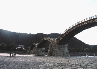
R 187 runs along a river in the forest, with fewer cars and gentle ascents. Enjoy biking in bracing, fresh air. Passing the peak Boujiga, take R 187, then take R2 to left, you will soon arrive at Iwakuni City(岩国市) near Seto Inland Sea(瀬戸内海). There is a very famous bridge before entering the center of the city, near the youth hostel, its name is Kintaikyo Bridge(錦帯橋).
This is a masterpiece of Japanese wooden architecture; and surely one of the most beautiful bridges in the world. It is composed of five connected wooden arches and its length is 193m.Not a single nail was used in its construction and all fastenings are of wood. This structure is very special and almost unique and the bridge is visited by numbers of architects from all over the world . Next to the bridge there is a large park "kikka Kouen" and a good place for bush camping. Please be careful with your fire and sleep well. "Length of Japan",Japan Cycling route Network takes along Seto Inland Sea via world heritage Miyajima , ground Zero Hiroshima and Shimanami Sea road ...to kyoto. Another Route Recommended !Oomi jima islandOomijima (青海島) is an island known for its strange rocks and bizarre stones. The stones are located along the coast, so we recommend seeing them from a pleasure boat, though you can ride along the land-side of the shore if you want. The pier for the sightseeing boat is at "Seaside Square (シーサイドスクエア)" which is in Nagato-shi Yamaguchi prefecture. Aim for JR Nishizaki St., then look for the signs to Seaside Square .
Route
Climate data for Fukuokauploaded:14, 04, 2019
|
|||||||||||||||||||||||||||||||||||||||||||||||||||


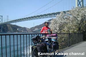 Kanmon Kaikyo Channel is the meeting point of the Japan Sea and the Pacific Ocean. Each sea has different timing of tides so this channel has TWO sets of tides each day and the waterflows from these tidal movements are very rapidrapid. (Note: “Kanmon” in Japanese is a combination of “Kan,” a short name for Shimonoseki city on the Honshu side, and “Mon,” a short name for Moji city on the Kyushu side. “Kaikyo” is a Japanese word for channel.)
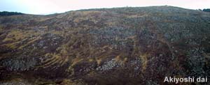 Next destination is Akiyoshi Dai, which is the largest limestone "karst" tableland in Japan.
 Makurase camping site, Nichihara. 400 yen per night
 Kakinoki village, 13km from Nichihara is a ggod example. There are two reasonable and plain Onsen houses to stay atto have a closer appreciation of and communication with these aged village people.

|
|
|
Copyright "Japan Cycling Navigator". All
rights reserved.
|
