
|
|
|
|
Ads by Infohub
Partnership with TGCT
Mutual Support with JCA |
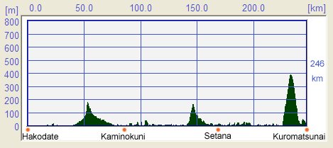
Length of Japan:Hokkaido
1.Hakodate to KuromatsunaiMap of this RouteSummary
Profile Map
DetailHAKODATE - The Gateway to HOKKAIDO
If you arrived via the overnight ferry, you might want to try an early-morning market which is just in front of the Japan Railways Hakodate station. Cuttlefish caught locally in the sea around Hakodate City are special local delicacy and are highly recommended. A local specialty called "Izushi"(飯寿司) which consists of pickled fish and vegetables is particularly worth trying. One of the main sightseeing attractions in Hakodate City is the area which stretches from the waterfront; where you will see warehouses of red bricks, to Motomachi(元町); where you will find a row of Western-style buildings. Motomachi, a town on the slope of a hill, is especially scenic. Hakodate City is where you will find some of the top class museums in Hokkaido Prefecture. Among these you would not want to miss visiting the Museum of the Northern Peoples(北方民族資料館). Original objects (rather than replicas) are on exhibition and it would be worth your while for you to take time to see them. When you leave the Museum of the Northern Peoples and go up "Motoi-zaka,"(基坂) take a look at the green space on your right. This is the remnants of the Usukeshi Kono House(宇須岸河野館). Many traces and ruins of forts remain in the southern Hokkaido. These are called "tate,"(館) (meaning a manor house, and which sometimes changes to "date" depending on the word preceding it. Remember to pronounce the final "e"). Because of its square, boxy shape, people began to call Usukeshi Kono's House "hako date," which literally means "boxy house" and that is the origin of the city name; "Hakodate." But, there is another story about the name "Hakodate" which is that it came from the Ainu word "Hak-casi," which means "a shallow fort or a small manor house" in English. The Ainu are one of the original inhabitants of the Japanese islands and small numbers still survive and pursue their traditional way of life. Hakodate has a lot of other attractions and some of the most popular places to visit are; Goryokaku Fort(五稜郭), a western-style castle in the shape of a pentagon, a Trappest Monastery(トラペスト修道院) and at the Hakodate City Museum(市立函館博物館) you can see over 370,000 old coins which have been discovered in the Zenigamezawa district. If you wish to visit remnants of "tate" or manor house in southern
Hokkaido, Shinori House, situated south of Hakodate airport, is
recommended because it is kept in good condition and you can easily
imagine how it looked like in bygone days; near by.
Cycling from a "tate" to "tate"
Your destination for the day would be Kaminokuni Town(上ノ国町) on the Japan Sea reached on a road with light-traffic leading through a low pass which will be a comfortable ride for you. Once you get to Kaminokuni, you might want to go on up Mt. Iou(夷王山). In the
Mt Iou there are the ruins of Katsuyama House(勝山館), a government-designated
historic site. For a long time this has been thought to be a Japanese
fort. However, it is interesting to note that hunting equipment
apparently used by the Ainu have been found, and also Ainu graves have
been found in the Japanese-era cemetery.
Cycling north with reminders of Kitamae-sen
When you arrive in Esashi Town, you might want to visit Kamome Island where there is a restored warship called Kaiyo-maru, which sank at the Boshin War (1868-1869) exhibited. Strolling around the picturesque island would be rewarding too. "Esashi-Oiwake," Esashi's folk song, is popular in this region. A contest is held every year and singers come from all over Japan. Another big festival held in Esashi Town is what is called "Ubagami-Daijingu-Togyosai"(姥神大神宮渡御祭) (held in August 9th through 11th), which was derived from the Gion Festival in Kyoto. Esashi Town, with normally only 11,000 residents, expands to 60,000 people during the festival. When in Esashi Town, you might want to take a side trip to Okushiri Island. The island was hit by a tsunami on July 12th, 1993, which left it severely damaged. You can see from the height of the seawall built as a countermeasure after the tsunami how devastating it was. When you cycle from Esashi Town to Setana Town(瀬棚町) and go further north along the coastal you will enjoy continuously beautiful scenery. The typically picturesque shore of the Japan Sea is especially beautiful around Shimamaki Village(島牧). Numerous attractive hot springs occur along this stretch of the coast of the Japan Sea.and you might want to slow down to enjoy some hot springs hopping. Taking a side trip to Garo Falls(賀老の滝) in Shimamaki Village would be rewarding if you have a little time. It has been chosen as one of the top 100 water falls in Japan for its magnificent view as well as being the biggest water falls in Hokkaido.
From Honmoku(本目), a shortcut to Kuromatsunai Town is recommended because you
can take in some amazing scenery on the way over a pass, though the
altitude is only 400 meters. As an alternative route, if you wish to
save your energy, going through Benkei Cape(弁慶岬) in the north is recommended.
Another Route Recommended!ّAlternative Route: HAKODATE to ONUMA
That does not mean, however, that the Lake Onuma route should be ignored or is less popular. Quite the contrary. The view of the calm lake with the towering Mt. Komagatake in the background is unforgettable. Another thing that makes the Lake Onuma route popular is that the Higashi Onuma Campsite on the lake is open to the public late April through late October and is free of charge.
If you decide to give Hakodate to Lake Onuma route a try be brave enough to
take Route #5, which although rather busy is a lovely road lined with
Japanese red pines, which has been chosen as one of the top 100 roads in
Japan.
Geographic names from the Ainu language
Incidentally, geographic names of Ainu language origin are found in much of the north of the Japanese islands from the northern Tohoku region on the main Honshu Island, up through Hokkaido and further north to the Kurile Islands and even on to south Sakhalin occupied by Russia. When you come near to a river in Hokkaido Prefecture, watch for a sign board about the river, which, in many cases, will contain information that describes the origin of the name, (though in Japanese).
Talking about geographic names originated in the Ainu tribe’s language, Mr.
Hidezo Yamada (山田秀三) (1899-1992) (whose career included time as a government
bureaucrat, and president/chairman of Hokkaido Soda) plays a great part.
Many sign boards describing the origin of geographic names, cite him as the
author of the main book from which the explanation of the name of the river
or place is taken. He is very famous for his study of the geographic names
inherited from the Ainu language. If you drop in on a bookstore in Hokkaido
Prefecture, you might want to look for his books on the geographic names in
Ainu which are very interesting as general reading too.
"Nai"(内) and "Betsu"(別)The two words “nai” and “betsu” are the bare minimum for you to remember. Both of them are Ainu origin and both mean a river. The fact that you see “nai” or “betsu” in so many of the geographic names in Hokkaido Prefecture reflects the life style of Ainu, who lived close to the river and relied on food from the river. The Ainu origin of so many places and features remain a fascination for experts in Ainu study as well as being of interest to amateurs and general readers.
Route
Route Summary
(Red: National Route, Green: Prefecture road, Yellow green: cycle path, gray: other roads) Web ForumYou can disccus about cycling in Japan in Japan Cycling Navigator Facebook group AcknowledgmentsThis section is translated with great help from Ms. NAGAI, Ayumi and Mr. Paul Phenix. Our cordial thanks to them; and also to our other supporters and helpers. (Hakodate ---> Kuromatsunai) Forward to (Kuromatsunai ---> Sapporo) uploaded:14, 04, 2019 |
|||||||||||||||||||||||||||||||||||||


 Most cyclists who set out to tour southern Hokkaido
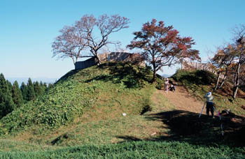 After leaving Hakodate City in a west direction, heading for Kikonai
Town
After leaving Hakodate City in a west direction, heading for Kikonai
Town From Kaminokuni Town, the road runs along the scenic coast of the Japan
Sea. The area facing the Japan Sea in this part of Hokkaido is known for
its prosperity in the past which was created by the Kitamae-sen
From Kaminokuni Town, the road runs along the scenic coast of the Japan
Sea. The area facing the Japan Sea in this part of Hokkaido is known for
its prosperity in the past which was created by the Kitamae-sen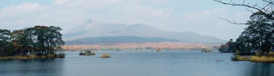 There are actually two possible routes out of Hakodate to start your
Hokkaido trip; an alternative route is Hakodate to Lake Onuma (“Big Lake”)
There are actually two possible routes out of Hakodate to start your
Hokkaido trip; an alternative route is Hakodate to Lake Onuma (“Big Lake”) Although written in Kanji (Chinese-origin) characters, the geographic names
in Hokkaido Prefecture are often difficult to pronounce for the typical
Japanese person. In fact, they sound quite exotic as many of them are,
needless to say, inherited from the language used by Ainu tribe, the
indigenous population in Hokkaido Prefecture, and have been phonetically
translated using Kanji.
Although written in Kanji (Chinese-origin) characters, the geographic names
in Hokkaido Prefecture are often difficult to pronounce for the typical
Japanese person. In fact, they sound quite exotic as many of them are,
needless to say, inherited from the language used by Ainu tribe, the
indigenous population in Hokkaido Prefecture, and have been phonetically
translated using Kanji. Takipedia
|
|
|
Copyright "Japan Cycling Navigator". All
rights reserved.
|
