
|
|
|
|
Ads by Infohub
Partnership with TGCT
Mutual Support with JCA |
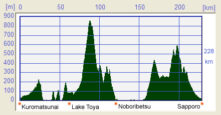
Length of Japan:Hokkaido
2.from Kuromatsunai to SapporoSummary
Map of this RouteProfile Map
DetailKuromatsunai(黒松内), Northernmost forest of Buna(beech)Arriving in Kuromatsunai, which is the northern edge of the Buna (Beech) Forest, you can easily access the beech forest from the Buna Center (Kuromatsunai Beech Tree Museum)(ブナセンター). Although the Beech Forest in Utasai is primary, undeveloped forest, you can explore it quite easily as there are no extreme, steep hills; unlike, for instance, the other beech forests in Shirakami mountain district in Aomori prefecture. You can walk around in the forest without difficulty. From Kuromatsunai, take Prefecture Route #266 to Uchiura-wan (Volcano Bay)(内浦湾). This route has quite steep ups and downs even though it runs along the sea coast. Turn left onto prefecture rout #609 after descending the Rebunge peak. You will find Kamui-casi (カムイチャシ) along the coast. This is the best spot to take rest for a while.
Uchiura-wan (Volcano Bay) (内浦湾(噴火湾))
The shell mounds were originally though to be "middens"(rubbish dumps) of the Jomon eras. Nowadays, it is established that the shell mounds were sacred ground.
Arutori Cape has an isolated camp site which is recommended to those seeking to be away from crowds. Nishiyama Wild Volcano
Although the Lake Toya Hot Spring had to close for 8 months after the eruption in 2000, the hot spring has now recovered and re-opened. Visitors can enjoy the "long run" fireworks during the summer season which is a fireworks display which takes place every evening during the summer. Take the road to Orofure Pass(オロフレ峠) even tough it will be a bit of hard work. The altitude of Orofure Pass is 940 m but there is much less traffic and beautiful forest scenery. After your hard (and sweaty!) work, you can look forward to Noboribetsu and the relaxation of its hot spring. The Noboribetsu hot spring(登別温泉) area offers a number of day spas. The most famous of these is Dai-ichi Takimotokan(第一滝本館). But the whole area swarms with hot springs. If you are limited in budget, the Yumoto Sagiri-yu(夢元さぎり湯) is recommended as it is quite reasonably priced and has quality hot spring water.
After relaxing in a hot springs, make an extra effort to visit Oyunuma(大湯沼) where there is a good nature trail. Lake Kuttara(クッタラ湖) is another sightseeing spot. A quiet, narrow road, which is impassable to the big sightseeing buses, will take you to the heart of Hokkaido's natural beauty. Don't pass up riding up to Lake Kuttara. Satisfaction guaranteed!!
The way to Lake Shikotsu(支笏湖)
Lake Shikotsu(支笏湖)
On the way to the Lake Shikotsu, there is a route to the bottom starting point of a trail up to Mount Tarumae(樽前山), famous for its huge lava dome. Mount Tarumae is still an active volcano and access to this lava dome is forbidden. The stark mountain scenery denuded of trees is an eerie but impressive sight.
Lake Shikotsu is the northern-most ice-free lake and amongst the clearest lakes in Japan. It is amazing to realize that nature of this majesty can be accessed from a million-people sized city, Sapporo, in a one-day bike trip.
The next must-see place is Lake Okotanpe(オコタンペ湖) which is famous as one of three rarely-visited lake in Hokkaido. This is because Lake Okotanpe has limited access by reason of being in a Forest Ecosystem Reserve. The Japanese government is trying to protect the environment around this lake for the future and so, you can not get access to the lake shore, however, you can enjoy and appreciate the natural beauty of the area from the Reserve’s observatory. The way to Sapporo(札幌)
When you enter Makomanai(真駒内), take the cycling route along the Makomanai River which will lead you on to the cycling road on the right bank of the Toyohira River.
If you will be riding the opposite direction, from Sapporo to Makomanai, take the road on the right bank of the Toyohira River and this will lead you to the road alongside the Makomanai River mentioned in the earlier paragraph.
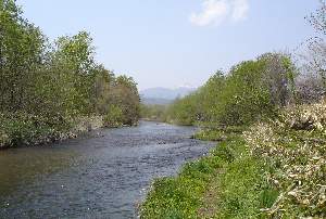
Not to be missed!!Uyoro River foot path(ウヨロ川フットパス)
A map of foot path is available at the Kiosk of JR Shiraoi station(JR白老駅). Information on the foot path can also obtained at Ocean Farm(オーシャンファーム), located where the highway crosses the Uyoro River. Horse riding is also available at Ocean Farm. Tarumae Garou(樽前ガロー)
Tarumae Garou which is a narrow gorge or gulley which the river ruches
through can be accessed by bicycle. RouteRoute Summary
(Red: National Route, Green: Prefecture Route, Yellow green: cycle path, gray: other roads) Web ForumYou can disccus about cycling in Japan in Japan Cycling Navigator Facebook group Back to (Hakodate ---> Kuromatsunai) Kuromatsunai ---> Sapporo) (Sapporo ---> Asahikawa) uploaded:14, 04, 2019 |
|||||||||||||||||||||||||||||||||||||||||||||


 Kuromatsunai Beech Tree Museum[J]
 When you reach Toya, we recommend you to go to Usu Bay in Date City
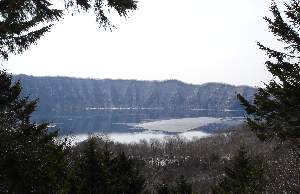 To get to Lake Toya
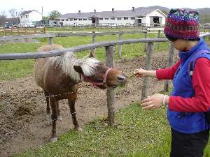 You have to take the busy route from Noboribetsu to Tomakomai but there are some old local roads alongside the main traffic road for part of the way.
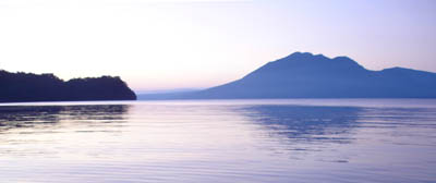 Take the Prefecture Route #141 in Tomakomai
 Heading north on National Route #453, it is just 30 km from Lake Shikotsu to the city of Sapporo. This route has a number of ups and downs. It is known as the "Gateway to Success" for sporting cyclists in Sapporo. Many road-bike racers use this route for training.
 This foot path is located beside the Uyoro River near JR Hagino station
|
|
|
Copyright "Japan Cycling Navigator". All
rights reserved.
|
