
|
|
|
|
Ads by Infohub
Partnership with TGCT
Mutual Support with JCA |
Fukuoka - Tokyo : Attractive route with many attractions
Over the sea by bicycle to Shikoku Island (Onomichi-Takamatsu)Summary
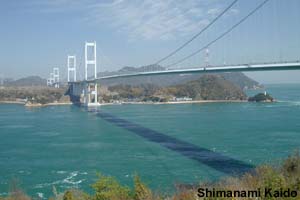
DetailCycling on the sea via Shimanami Kaido
Shimanami Kaido Bridges are the ONLY bridges which cyclists can ride across between Honshu and Shikoku (between the Hiroshima and Ehime prefectures). Others are prohibited to bicycle riders. Shimanami Kaido, which means "Islands Sea Road", connects SEVEN islands to get to Shikoku, about 65 km. These bridges have dedicated bike paths enabling you to be separated from the motor vehicle traffic. The route might be described as "One of the world’s best short bike rides". Japan is formed from about 400 inhabited islands and many of the small islands are located in this inland sea. It is said that Japanese culture is based on the agrarian society, but actually Japanese culture is formed by many kinds of folk cultures, such as Ainu (native Japanese in Hokkaido), Matagi (Hunters in Tohoku), Okinawan culture, Fisher and Islanders and so on. This Sea Road is one of the best courses to experience those Fisher and Islanders cultures by bicycle in Japan. Here, there are descendant of pirates and people who lived their entire lives on board boats. Why not stay one night at one of these attractive peaceful islands. You might become the first non-Japanese cyclist to visit and enjoy the unique atmosphere. So magnificent is this bike route, if the weather is favorable, you won’t want to hurry anyway. Climb the steps to Konpira Shrine
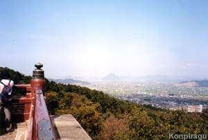
This pilgrims first arrived in the 12th century. A famous high Buddhist monk Kukai (空海) also known as Kouboudaishi (弘法大師), born in the 8th century, traveled Shikoku to save the peoples’ soul. The 88 places where he had stayed became sites for temples, and pilgrims are still tracing Kouboudaishi’s route. By visiting those 88 temples, it is said you will be free from 88 painful passions and desires, and you will have also done 88 good works for the world and yourself. Although walking is the traditional way, many people visit the 88 temples on a bus tour or taxi. Of course a bicycle is ok too – and the next best thing to walking. After arriving Imabari City, take seaside Prefecture Road 38 and R 196 to the east, viewing the Seto Inland Sea on your left, then take prefectual road 13 at Saijo City. R 377 is heading to the famous shrine, Sanuki Konpira-san. It is located at Shoto Mountain, on the west side of Kotohira Town, and enshrines the goodness of the sea. This shrine is famous for returning many kinds of happiness to its visitors. For this reason it is a favorite shrine for Japanese people. From the entrance there are 785 steps to climb to the main shrine, and to reach the highest-shrine there are another 1368 steps. You will experience many cultural features, and as you ascend panoramic views of Seto Inland Sea will open up, including the Sanuki Plain with its many small lakes. The goal of NOODLE ROAD
You will find lots of small ponds marked on your map. Can you guess what they are for? They are artificial ponds. This area has the least rainfall in Japan. The ponds (actually water reservoirs) were the solution to water shortage. There are about 14,000 ponds and they identify the unique Sanuki Plain landscape. Even when it does rain, the water goes directly to the sea in the Yoshino River. Even today those living on the Sanuki Plain have difficulty reserving water for living and farming. This distinctive climate has developed a tasty culture. This is the Sanuki Udon Noodle (讃岐うどん). The Japanese staple food is rice but this area is too dry for paddy rice growing. Instead of rice cultivation, the Sanuki people work hard to produce wheat from which they have developed a tasty noodle made from flour. Flour has its origins in Europe and was introduced into China along the SILK ROAD. Chinese People invented a flour noodle which migrated to Japan via Korea. In turn, the noodle also became popular in Europe. The Sanuki Area is at the east end of NOODLE ROAD (as named by Japan Cycling Navigator) that connects the Far East, i.e. Japan, with Europe. You are on that east end. Congratulations! Sanuki Noodle’s soup is made of tuna and seaweed, very tasty and also inexpensive. It may cost as little as 150 yen for a bowl of plain noodle. You will hopefully remember Sanuki for its frequent good weather and tasty noodles. Route
Climate data for TakamatsuLinkThis web site have lots of informations about cycling in Hiroshima prefecture
uploaded:07, 04, 2019 |
|||||||||||||||||||||||||||||||||||


 Three routes utilizing a chain of impressive bridges island-hop the Sea of Seto between Honshu and Shikoku Islands. Seto-Ohashi Bridge connects the Kagawa and Hyogo Prefectures. Akashi-Ohashi and Naruto-Ohashi Bridge connect Hyogo and Tokushima Prefecture across Awaji-Shima Island.
 Imabari City is the destination of the Shimanami Kaido route and the start of the "Length of Japan" leg in Shikoku Island. Shikoku is the fourth largest island in Japan. It is famous for its 88 temple pilgrimage. While you ride around Shikoku you will meet some of the pilgrims
 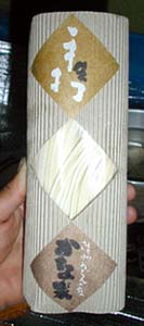 After Kompira-san temple, ride through the Sanuki Plain (to the east) to Takamatsu City, the center of Kagawa Prefecture.
 MTB Trails Guide in Hiroshima[E]
|
|
|
Copyright "Japan Cycling Navigator". All
rights reserved.
|
