
|
|
|
|
Ads by Infohub
Partnership with TGCT
Mutual Support with JCA |
Fukuoka - Tokyo : Attractive route with many attractions
(Kyoto-Gifu)Summary
DetailLeave ancient capital KYOTOThe roads between Kyoto and Tokyo developed rapidly from the beginning of the Edo Era when Tokugawa Shogun moved Japan’s capital from Kyoto to Tokyo. There were two main roads; the Tokaido Way and the Nakasendo Way. Tokaido, along the Pacific Ocean, is these days the R 1. Nakasendo goes inland and you can trace it on R 1, R 21, R 19, R 18 and R 17. Both are still used as important main routes between Kyoto and Tokyo. Our "Length of Japan" does not, however, recommend those routes. Instead we lead you to Tokyo via the World Heritage village of Shirakawago, Japan Alps, and Nikko National Park. From Kyoto, take the R 367 to the north east. It goes to Japan Sea (on the Western side of Honshu) and is named the MACKEREL Way. Because Kyoto is surrounded by mountains, seafood was very precious for the Kyoto people prior to motorized transport arriving in Japan. Fisherman who lived near the Japan Sea had large catches of Mackerel (a blue fish) and preserved the fish with salt before carrying their product to Kyoto along this road. This road was once very busy street and you can still find traces of past. Ride 10 km along the R 367 from Kyoto and arrive a Sanzen-in (a famous temple). You will now be riding in forest. Ride another 5 km to reach the Shiga Prefecture border. Do not enter the tunnel but take a side road on the left and soon you will see road sign indicating a right turn onto the R 477 for Lake Biwa. After 7 km downhill you will see the big lake. This is the largest lake in Japan, Biwa-ko. Japan’s Largest Lake, Biwako-ko
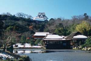
R 477 leads you to Biwako-ohashi Bridge (20 yen toll for bike). After riding across the bridge, turn left and take Prefecture Road 599 then Prefecture Road 25. It is heading to Hikone Castle, a National Treasure. Enjoy your ride along the lakeside road. When you approach Hikone Castle, taking the Prefecture Road 2 is fine. This road still retains traditional houses and shops. Now the houses are used as Japanese restaurants, coffee shops and souvenir shops. Hikone city is the last stop on the west side of Japan. Rest here for a bit and take a deep breath and enjoy the western Japan culture. If you want to ride further around Biwa lake, it is a good idea to ride the Oku-biwa Lake Park Way located north of the lake. Here is the beautiful scenery of Biwa Lake, especially from the hilltop. Division of Kyoto and Tokyo Culture at Sekigahara
Passing the summit of Sekigahara you will enter Japan’s third largest urban area, Nagoya. Already, riding this "Length of Japan" route from Fukuoka, you have entered three large urban areas, Fukuoka, Osaka, and Nagoya. Finally this "Length of Japan’’ goal is Japan’s largest urban area, Tokyo. We hope you enjoy contrast between urban and rural areas by riding along this byway. Urban cultures vary and Sekigahara divides the culture of west side (Fukuoka and Osaka) and east side (Nagoya and Tokyo). For example, if you have Miso Soup during your Japan travels (Miso is Soybean paste) you will find a change of taste in Sekigahara. Miso flavor in West Japan is light and the color is cream. In Nagoya the flavor is stronger deep and color is brown. The color of Miso will not change until you get into Tokyo, or Aomori at the edge of East Japan. Sekigahara may still be a battlefield, but of intriguing Japan Culture rather than violence. Ride down along R 21 (30 km) to Gifu City, then turn left at an intersection of the R 21 and R156 in order to avoid heavy traffic. But you cannot avoid the hill roads to Japan Alps where Japanese cyclists love to ride. Good luck for the good rugged mountains. Another Route Recommended !Site of Reversible Destiny - Yoro Park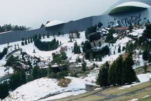
Route
Climate data for Kyotouploaded:14, 04, 2019 |
|||||||||||||||||||||||||||||||||||||||


 Biwa-ko has an area of 647 sq km and is 200 km around. It is a popular location for bikers and especially an annual biwa-ko cycling event.
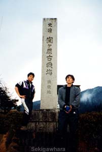 From Hikone, take the R 8 (10 km) then the R 21. You will reach Sekigahara. Sekigahara was the largest battlefield in Japanese history when, in 1600, Tokugawa Shogun ended the Age of Civil Wars related to the Samurai period. The Edo Era began and a peaceful era, free from civil wars, continued for 300 years.
 Site of Reversible Destiny - Yoro Park[E]
|
|
|
Copyright "Japan Cycling Navigator". All
rights reserved.
|
