
|
|
|
|
Ads by Infohub
Partnership with TGCT
Mutual Support with JCA |
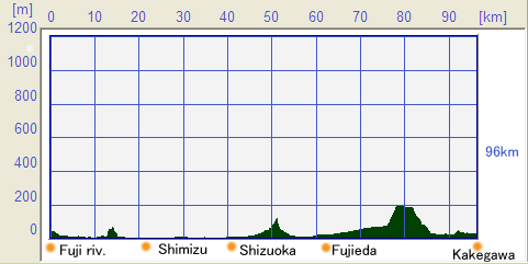
Length of Japan : TokaidoAlong Old-Tokaido : Fuji river - Kakegawa city (96km)Map of this routeSummary
Profile map
DetailChoose the route Keeping away from heavy trafficFrom the Fuji river to Kakegawa, there are traditional streets and historical buildings which retain the atmosphere of the Edo era (Edo was the imperial capital before Tokyo). On the other hand, in this region the mountains come closer to the sea shore than other section of the JCN Route.This means that most almost traffic is crammed onto the National Route 1. So, we suggest taking a diversion so as to avoid congestions. Essentially, the JCN Route tries to mirror the old Toukaidou which was the 514 km (319 mile) road and chain of 53 rest-houses which linked Edo and Kyoto from the Edo era onwards. Essentially the suggested Route parallels R396 South from the intersection at Fuji river bridge. However, the areas along the main road are very developed and populous. .  By climbing the old fashioned side streets near the Fuji river crossing points, you can ride to Iwabuchi Ai-no-shuku(岩淵間宿) (Shuku means a group of accommodations, shops, etc. of the Edo-era). This road meets up with R396 in front of the Fujigawa station of the JR railway. In the next “shuku”, at Kanbara-shuku(蒲原宿) it is suggested that you follow the back street on the mountain side of the main road: but that at Yui-Shuku(由比宿) you choose the back street on sea side of the main road. At both places, the historical buildings and atmosphere are well preserved. Satta pass which provide you one of the best view of Mt.fuji After going through Yui-Shuku, the JCN Route re-meets R396, you are able to see the traffic sign “turn right to Satta Pass(薩埵峠)” (refer to photo attached). It is not very easy to find out route through the junction (see next paragraph). In case you make a mistake and go straight without making turn right, you will eventually meet Expressway R1 finally. You are recommended to retrace to the junction so that you can stay with traditional areas. At the junction with the sign for the Satta Pass and then turn left at the first intersection.  At the end of this small town, there is another junction .The very steep slope in front of you, seems to mean that a bicycle cannot proceed up this slope. An easier way would seem to go to the left way but this leads National Route 1, Highway. But you should appreciate that however, this steep slope only lasts for 100m distance, and if you cannot ride the Route, you can just walk it with your bicycle. We recommend that you choose the hilly way, rather than the crowded National Route 1.  Soon the road side scenery changes to farming villages that grow oranges, so that the Route becomes surrounded by Orange fields. The road is concrete rather than tarmac. For a while the Route continues to ascend and as it does, you should keep an eye open behind where you will be able to see Mt. Fuji and Suruga Bay(駿河湾). Up this slope is Satta Touge, one of the best view points for Mt.Fuji. There are rest rooms and viewing platforms to take in the beauty of Fuji. through the city and reach the coast rine Leaving Satta Touge you will see the way back to the Express Way on your left. The JCN Route descends for a while, then meets a T junction where you should turn left and then make a right turn just before crossing Express Way. You will see a huge tree and cross an old stone bridge. This shopping area is Okitsu Shuku(興津宿).and acts as a by-pass for National Route R1 as it goes parallel to R1. Traffic becomes much lower and you are able to ride more easily because a reasonable road width is maintained. After leaving Okitsu Shuku and crossing the bypass of the National Route R1, the road becomes narrower again. Unfortunately there is no alternative comfortable choice, so the JCN Route has to follow R1 for a while. Up to this point, we have been following roads through towns that have preserved original, traditional characteristics of Tokaidou. But from here onwards the route and areas, in the Shimizu(清水) and Shizuoka(静岡) areas, they are developed and modern city. So, we had shifted the Route to the sea side instead, as soon as practical. The National Route R1 goes to the left from in front of Shimizu railway station, but we keep going straight along the National Route R149. There is still considerable traffic and be warned that Route 149 changes name to Route 150 without notice, but you can keep going along this way.  This particular part of the National Route R150 is often called Ichigo-Line (Strawberry Road)(いちごライン) since lots of strawberries are produced in the area. You can go strawberry picking if you wish. Be advised that, there are heavy traffic jams during the high season. Currently this part of the National Route R150, is being re-aligned. Most of the construction work is supposed to be completed in March 2008. The old R150 will still exist and should become bicycle-friendly route. Passing through more strawberry farming areas you will meet a T junction. At this T junction you will see the road goes ahead, but under construction. The route you are able to follow will depend upon the progress of the new alignment of the road. At the time of writing, you can choose the Shizuoka Ouhashi/ Bridge(静岡大橋) between the bridge across the Abe Rver(安倍川) (on the R150) and the bridge on the National Route1. the most oldest [on-charge] tunnel in JapanTaking the Shizuoka Ouhashi Bridge and proceeding straight on, there is resting point from the days of old-Toukaidou,"Mariko Juku(鞠子宿)". There are not many preserved traditional style of buildings, but at the west end of Mariko Juku, there is a rest house (tea store) "Choji Ya(丁子屋)", which has a straw roof. It is suggested you have a cup of tea before setting off for the mountains. You need to take the bridge just in front of Choji Ya and go along Route 208. There will be an intersection with the National Route R1 where you turn left and keep going on R1. When you can find the Michinoeki (Road side station) "Utsunoya Touge(宇津ノ谷峠)", you need to turn left at the end of this building. On the side away from R1 there is an old Toukaiou route.  The entrance to the Utsunoya Shuku(宇津ノ谷宿) area is a Y-shaped junction. If you choose the left fork, you go along a slope paved with blocks of stone and a tunnel built during the Meiji Era(明治時代) (This is the first tunnel which is [on-charge] in Japan). The right fork is a road which acts as a bypass for Utsunoya Shuku and this road has another tunnel built in the Taisho Era(大正時代). Whichever way you choose, the two roads come back together. From this point until Kanaya Juku(金谷宿), we will be following National Route R1. However, there are some sections of old Toukaidou preserved parallel backstreets, and so we may follow some of these backstreet to give a taste of Toukaidou. After some distance on Route 208, you come to a T junction. This marks the end of Route 208 and you should turn right to go back to the National Route R1. When you reach R1, turn left and you will reach a Y junction at the first traffic signal. Please proceed to the right, where narrow streets will take you to Fujieda Juku(藤枝宿), where the glory days of Toukaido are well preserved. In the center of Fujieda Juku is a market built during Showa era. This will show you a typical town scene of Japan. Past the shopping street and across a small Bridge, the JCN Route meets the National Route R1 again. This is a 5-way intersection, and you need to go the narrow route directly opposite.  Again this is part of the old Toukaidou route. through the green tea producing areaGoing through Shimada-Juku(島田宿), just in front of Shimada railway station, the Route merges with Route 381, just before the Ooi river(大井川). On the south side of the Ooi river bridge, there is a track for walker and cyclists and it is best to use this track. After crossing the bridge and riding for a while you will come to a junction with the National Route 473. At this point to turn left and you will be heading for the Makinohara uplands(牧之原台地), famous for its tea plantations.  R473 begins to ascend the slopes before the Kanaya railway station and this climbing continues for a while. But as compensation you are able to enjoy excellent views of the Ooi river and Fujieda city, Yaizu city(焼津市) and the Suruga Bay area, so you will forget your fatigue. At the top of this climb, tea plantations are spread all around Makinohara the highlands. The tea production from this area is the one of the highest in Japan. Unfortunately the road is quite narrow. There is a tea museum, “Ocha no sato”, which is quite interesting. You should keep to Route 79 and after passing Kikukawa railway station(菊川駅), turn right to Route 37. For a while the flat road continues and you will reach the center of Kakegawa city(掛川市). In this city there is Kakegawa castle which has a "Tenshu kaku(天守閣)" (main tower) which you are recommended to visit.
uploaded:07, 04, 2019 |


|
|
|
Copyright "Japan Cycling Navigator". All
rights reserved.
|
