
|
|
|
|
Ads by Infohub
Partnership with TGCT
Mutual Support with JCA |
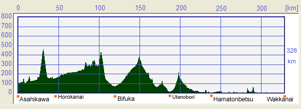
Length of Japan:Hokkaido
4.North from Asahikawa to WakkanaiSummary
Map of this RouteProfile Map
DetailHome of Soba noodles
The Uryugawa river originates from the largest artificial lake in Japan, Lake Syumarinai(朱鞠内湖). Along this river, there ran the Shinmei railway which connects Nayoro and Fukagawa. They were constructed in approximately 1940 with back-breaking works. At least 204 people died, and 36 people of them were from Korea that was one of Japanese colonies at that time. Today you couldn't imagine such an horrific past from the face of beauty presented by Lake Syumarinai. Indeed, it does not look at all like it's an artificial lake. Moshiri(母子里) district near the lake is known as a place that recorded the lowest ever temperature in Japan. (-41.1 degree Celsius). It is also famous for its sparkling "diamond dust" surface. You may encounter a “Sun Pillar”, on which the diamond dust shines by the reflected light of the sun, even at midwinter. The northern-most point of rice cultivation
Rice cultivation was introduced into the southern part of Japan about 3,500 years ago, and it gradually moved north and now Bifuka is the end point of that long journey. Along the Bikou Rail Trail(国鉄美幸線)
If you like off road dirt riding, take Douhoku Super Rindou(道北スーパー林道) from Bifuka. It's official name is Bifuka Utanobori Long Forest Road(美深歌登大規模林道). In some sections you should take care not to lose control of the bike in patches of soft railway ballast, but you will enjoy Hokkaido's forest to the full. Also, beware of brown bears around Kasumi Pass(加須美峠).
Panning for gold
Among these sites, Usotan-nai Sakin Saikutsu Kouen(ウソタンナイ砂金採掘公園) in Hamatonbetsu Town is recommended. It costs only 500 yen including rent of the digging/panning equipment and tuition. The method of digging/panning is the same as employed by the old-time gold diggers in former times. You will use a "Kattcha" (small hoe/plow) and a "Yuri Ita" (flexed board). You can choose between two locations and tecniques: the Kawabori course which involves digging/panning in the actual river with no time restrictions; or the Suisobori course which is on an artificial water "flume" which, because it is easier or more popular has a 30 minute restriction. Don't worry if you run out of time or daylight because you become fixed on digging/panning, because you can camp here.
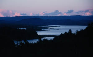
Lake Kucharo(クッチャロ湖) near Hamatonbetsu Town is a designated wetland under the Ramsar Wetlands Convention and also has a beautiful camp site.
A Drama of the northern sea
The Indigirka was stranded in 1939, 1.4 kilometers offshore of
Sarufutsu Village. The Japanese authorities and people helped them out in the
face of death. Consequently this had been believed to be a touching
tale for a long time. But after Soviet breakup, it became apparent that
they were political crimes. Some point out that it was not only a
touching tale but also a political affair.
The northern-most point in Japan
Sakhalin is the next major island north in the island chain. The southern areas of Sakhalin were previously administered by Japan under a long standing agreement with Russia/USSR but were occupied by the USSR in the closing days of World War II. There are ferries from Wakkanai to Sakhalin which take about 6.5 hours. Although not on the LOJ route, from Nemuro on the north-east coast, the most southerly of the Kuril Islands ("the Kuriles" or Chishima to the Japanese) can be seen offshore , where the isalnd chain runs in an arc north-east up to the Kamchatka Peninsular. Japan still maintains claims over the four most southerly of the Kuriles also occupied by the USSR at the end of WWII. If you climb up the southern hill of Cape Soya you will find a memorial for the shooting-down of a KAL airliner in 1983 by the Soviet airforces. There is also a World Peace Bell made from coins from many countries and also a statue of Rinzo Mamiya who surveyed the whole of Hokkaido and Sakhalin Island at the beginning of the 19st century. The area around Cape Soya consists of many hills and valleys of gentle slopes that were created during the last glacial period. So, here we have completed our long "Length of Japan" journey. You can head on down to Wakkanai(稚内) and comfort and safety.
Not to be missed!!Rishiri(利尻島) and Rebun(礼文島) island
Mt Rebun is not so well know but is recommended It is easy to reach the summit and the views from the top are well-worth the effort. Rice growing in HokkaidoJapan is experiencing a surge in the variety and quality of Hokkaido rice stemming from improvements in the breeding of the plants. Because of its northerly latitude Hokkaido rice was not well regarded, even somewhat "unsavoury". The continued research into types and cultivation has largely reversed this poor image of Hokkaido rice. Today some consumers and businesses prefer Hokkaido-grown varieties to Koshihikari Rice which is widely regard as one of the best varieties of rice in Japan. The following is a representative list of the development of Hokkaido rice. You should really try these when you get a chance.
RouteRoute Summary
(Red: National Route, Green: Prefecture Road, Yellow green: cycle path, gray: other roads) PostscriptThis is the end point of our "Length of Japan" cycle route, but you don't necessarily need to end your journey here. After enjoying Rishiri and Rebun Island, why don't you go a little further to Sakhalin Island, Russia? There is a liner that connects Wakkanai with Sakhalin though it does not run all-year. Getting a visa for Russia is little bother in Japan. You can get it through a travel agency in advance. Sakhalin still has unspoiled, unpopulated nature some of which Hokkaido has lost. We would very grateful if could you give us your impressions of our “Length of Japan” route and site. Please tell us by e-mail or via our bulletin board. Web ForumYou can disccus about cycling in Japan in Japan Cycling Navigator Facebook group Back to (Sapporo ---> Asahikawa) (Asahikawa ---> Wakkanai) uploaded:14, 04, 2019 |
|||||||||||||||||||||||||||||||||||||||||||||||||


 Cross Etanbetsu path
 Getting over Bifuka Pass
 Take the cycle route along the disused , Bifuka railroad line. This "Narrow Gauge" rail-line was intended to connect Bifuka and Esashi, but it was discontinued while under construction. You can see the abandoned rail-bed , where rails have never been laid, on the north side of the Amanogawa tunnel
 Torokko Oukoku(tram driving)[J]
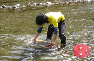 Take Prefectural Road 120 from Utanobori
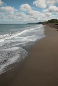 Leaving behind Lake Kucharo, go north along bleak but beautiful
coastline. About 30 kilometers from Lake Kucharo you will come to Sarufutsu Michinoeki (Roadside Station)
Leaving behind Lake Kucharo, go north along bleak but beautiful
coastline. About 30 kilometers from Lake Kucharo you will come to Sarufutsu Michinoeki (Roadside Station)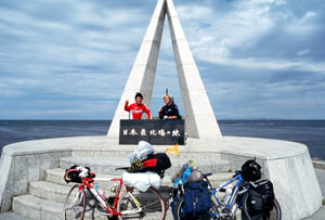 After passing by Higashiura
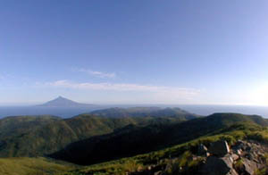 Cycling roads are well developed on Rishiri Island, but trekking up the island's mountains is also enjoyable. Mt. Rishiri is at near 2,000 meters elevation and sometimes it snows even in September. Prepare for the cold and set aside enough time to make the trek leisurely.
|
|
|
Copyright "Japan Cycling Navigator". All
rights reserved.
|
