
|
|
|
|
Ads by Infohub
Partnership with TGCT
Mutual Support with JCA |
Fukuoka - Tokyo : Attractive route with many attractions
World Heritages and Japanese Heritages (Iwakuni-Onomichi)Summary
DetailWorld Heritages : Itsukushima shrine and Hiroshima Ground Zero Dome
But these days the high tide level is rising (recent climate change thought to be one reason) and the sea often floods the floor level. So this is the time to visit, with your bicycle, and take a picture before flooding becomes a real problem. The boat fee from the mainland to the Miyajima Island is 270 yen including bike (one way). From Miyajima, you can see a big city, Hiroshima, which has a population of 1,200,000, the size of which you have not seen since you saw Fukuoka and Kita-Kyushu city.
The museum is one that needs to be visited by everyone worldwide. There is so much to see and comprehend.
The museum is one that needs to be visited by everyone worldwide. There is so much to see and comprehend.
(Comment added by cyclist Roy Sinclair who visited Hiroshima, from New Zealand, in 2000.)
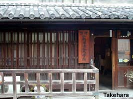
Edo-Style-Town "Takehara"
In this Inland Sea, there are hundreds of small islands. Most of tourist typically pass through these small islands and residents may not have experienced meeting non-Japanese cyclists in their home towns. There are hundreds to choose from.. Why don't you visit and possibly be a first cyclists from overseas?
From Hiroshima, ride along the R 2 for about 10 km to east then take the prefecture road 34 to Takehara City via Kumano town (there is a pass). Here we have introduced some historical preserved towns to the "Length of Japan" route. Takehara city is such a town but this one is different from others. This town has a 5 ha zone that has COMPLETELY preserved 120 houses of the late Edo era along the 400 m main street. Movie crews love to use this street for Samurai-related productions.
Temples and houses on the hill "Onomichi"After a brief stop in this Edo Samurai town, continue to ride 27 km along the seaside road R 185. Then take R 2 from Mihara City to Onomichi City. This city is the gateway to Shikoku Island. Entering this city, you will find many houses on the hillside on your left hand side. There are also 25 ancient temples on the hillside. Onomichi City was developed as a temple town so the paths on the hillside are so narrow they can be used only for pedestrian traffic. The paths are also confusing, like a maze. The houses and temples face south towards the Inland Sea, so this is a lovely location. It is a good idea to get off your bike and take a walk. A city map is available (maybe only in Japanese) produced by the Sightseeing Information Center located in front of Onomichi Station. There are several tours you can choose from, such as around the temples, a literature tour, and so on. For a finale, we recommend to climb Mt. Senko-ji on foot, not by cableway. It takes just half an hour to get to the top. From the top of mountain there is a panoramic view of the streets of Onomichi, Seto Inland Sea and Shimanami Kaido (highway of the bridges to Shikoku) where our "Length of Japan" is heading for ... Another Route Recommended. Kumano, a town of brush makingKumano is famous for its calligraphy brush industry. The brush is known as the "Kumano Brush". This town has an 80 per cent share in Japan’s calligraphy brush production that began 160 years ago. Surrounded by forest, craftsmen produce beautiful brushes every day. In this town, you can enjoy a display of the Four Treasures of calligraphy - brush, ink, ink stone and paper - and related crafts. Sakakiyama shrine in Kumano has a stone monument featuring the calligraphy brush. They also have a festival, thanking the forefathers and their spirits in every brush. Those who use the calligraphy brush regard it as a close friend, and even a part of themselves. So a worn-out brush is sent to the shrine where a prayer is said for its eternal retirement. Another recommended routeKakishima kaido and Tobishima kaido is well maintained cycling route along the coast. Route
Climate data for Hiroshimauploaded:07, 04, 2019 |
|||||||||||||||||||||||||||||||||||||||||||||||


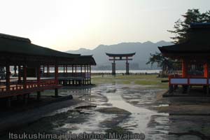 Ride to the north along the seaside flat and busy road, R 2, towards a large island. This is Miyajima Island, Itsukushima jinja, a World Heritage Shrine.
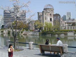 As everyone knows Hiroshima is the atomic bomb GROUND ZERO. Please visit the Hiroshima Peace Memorial Museum. We hope you stop and spend several hours here and ponder peace.
 Along the seaside road, you will enjoy the contrast of small islands and peaceful sea between Chugoku and Shikoku Island. This is called Seto Inland Sea. The current is slow, the climate is gentle through the year and the resources of fish and seafood are rich.
 |
|
|
Copyright "Japan Cycling Navigator". All
rights reserved.
|
