
|
|
|
|
Ads by Infohub
Partnership with TGCT
Mutual Support with JCA |
Fukuoka - Tokyo : Attractive route with many attractions
OVER THE MOUNTAINS:JAPAN ALPS(Takayama-Nagano)Summary
Caution!!The route which we introduce is open only after July when the authorities remove snow from the eastern side of Mt.Norikura. Before July you could be snowed in at the top of the mountain. At present moment, April 2008, a north part of Kamikouchi Norikura Rindo is closed to traffic due to cliff failure for several years by now. Therefore we off an alternative route, Abou-touge pass(安房峠) , as a blue line in our maps. The route is available from end of May, not congested and has fine views, too. Anyway, the JAPAN ALPS is where you will need to be careful of your physical condition. And always be aware of likely sudden weather changes. DetailRoad to JAPAN ALPS
In 1981 Walter Weston, a missionary from England and also a member of English Alpine Club, visited this alpine region. He was so impressed he used the name JAPAN ALPS in his Climbers Book which he edited in 1941. JAPAN ALPS became famous around the world by his literary work. When you approach from Takayama, Hirayu Pass (1684 m above sea level) would be the best entrance to the JAPAN ALPS. To the top NORIKURA
This route must be a CYCLISTS’ PARADISE. Of course the road is steep. But the more you climb, the better are the views of the distant JAPAN ALPS. Climb up to 2.500 m above sea level, above the timberline and you will see the long and winding road that you have pedalled. This road's summit, at 2.715 m, is the highest point on Japan’s roads. It is a popular ride for cyclists in summer. And with no private cars, the bicycle is the only vehicle offering the satisfaction of a self-propelled journey. At the top you will likely receive a warm applause from the Japanese tourists. After one hours easy hiking, from the road summit, you'll reach to the top of Mt Norikura. Then you can enjoy the down hill freewheeling to the east, heading to the Ichinose Highland where there is a large welcoming camping site. Cost is 400 yen for a tent site management fee for one night. Additionally, a fee for site ranged 1,000 yen to 2,000 yen depending on the type of site. (open from 1st/May to10th/Oct) NORIKURA SKY LINE is also the venue for a challenging annual cycling event held late August. into the heart of JAPAN ALPS:KAMIKOCHI
Ride the Kamikochi Norikura Rindo route (different from the NORIKURA SKYLINE) to the north from Ichinose Highland and you will get to the Kama Tunnel, the entrance to Kamikochi. You can get away from motor cars again here. Private motor vehicles are excluded from the Kamikochi road. But the Kama Tunnel has a steep grade (16-per cent) so you will have to pedal hard up through the tunnel and take great care. This tunnel has been excavated from the rock and part of it may (still) be in semi-darkness. After your half hour of hassle in the dark tunnel, you will arrive at the bright alpine national park. The beautiful Japan Alps are waiting for you, silently, and will appear in full view. Take a deep breath and see how beautiful the alpine world is. Many foreign climbers have visited this national park. You may happen to meet a climber from your country. Enjoy chatting in your native language. There is the KONASHIDAIRA camping ground (400 yen per one night) open from the beginning of April to the beginning of November. A visitor center near the camping ground offers information in English. There are many trekking courses. This is a great place to hike around (including longer day or multi-day trips) if you have the necessary trekking equipment. have a rest in the city
In Matsumoto city, you are free from steep mountain roads for a while. If you need some outdoor goods, it is better to stock up here. From Matsumoto, taking R 403 or R 19 to the east leads you to Nagano City which is remembered for the 1998 Winter Olympic Game in 1998. We suggest spending a little time in Matsumoto, especially. It’s a wonderful city with a traditional castle and mysterious narrow streets leading to stand-up bars and small eating places with great camaraderie. Nagano prefecture offers some of the best cities to visit in Japan.) R 20 to the south (from Matsumoto) is the way to Mt Fuji and a shortcut to Tokyo. These highland roads were upgraded for the Winter Olympic Games. The road condition is fine and a signage is in English as well as Japanese – obviously a great help for a visiting English-speaking cycling traveller. People who inhabit these highland areas including Matsumoto City and Nagano City have been living since early times with the gifts of nature. Among the attributes is the pure clear water. Then ride along R 403 or R 19 is heading towards Nagano City. We did pedal this route uphill from Matsumoto and I did notice early signs of hypoxia in Haruko and myself which is usually difficult to recognize. I do not think these tunnels have any forced ventilation? We stopped and rested on a high bridge between tunnels, and refueled on bananas, and were fine. We were absolutely exhausted when we arrived at Kamikochi. A couple of glasses of cold beer restored our health.
(Comment added by cyclist Roy Sinclair from New Zealand, in 2000.)
Another Route Recommended !Obuse Town
And if, by now, you have acquired a taste for sake (Japanese rice wine), how about a visit to the Masuichi-ichimura brewery(桝一市村酒造場). An American woman Sarah Marie is working here. Realizing Japanese people have lost much of their own beautiful culture, she took a position as a brewer during the Nagano Winter Olympic Games and began reconstructing the sake brewery in this traditional town. We can drink a glass of Japanese sake and be part of Sarah’s fulfilled dreams The sake label "Square one"(枡一) is named from her brewery. Several Obuse Town residents also open their own home garden’s to the public. Centuries ago this town was a center of commerce and traditional Japanese gardens are preserved by the residents.
Route
Climate data for Naganouploaded:14, 04, 2019 |
|||||||||||||||||||||||||||||||||||||||||||||||||||


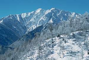 Ride through the ancient Samurai Castle town of Takayama City to the east, along the mountain route R 158. Beautiful mountains soon close in. Beyond these mountains are the Japan Alps, providing some of the most spectacular jagged mountains in Japan.
 NORIKURA SKY LINE (Hirayu Pass road to the top of Mt. NORIKURA) does not allow private motor vehicles. It is open to buses, taxis, and bicycles. This has been the rule since Autumn 2002, in an effort to preserve the environment, especially the alpine flora.
 From Mt Norikura, on a fine day you can see the beautiful curl of the JAPAN ALPS in the north. This is the next objective of our "Length of Japan" route, Kamikochi. The English missionary and mountaineer Walter Weston had been so impressed when he visited here in 1881 he named these mountains the JAPAN ALPS. (Weston had climbed in the European Alps and, in 1906, inspired the founding of the Japanese Mountaineering Club.)
 Check over your bike lights and light reflectors before leaving Kamikochi. R 158, connecting Kamikochi with Matsumoto, has a lot of long tu?nnels, luckily mostly on a downgrade. But for people riding the opposite direction to ours, it might be little trying, especially pedaling uphill with vehicle fumes in the tunnels.
 Obuse town is located 15 km east of Nagano City. This town is famous for its traditional storehouses and chestnut growing. Also, Katsushika Hokusai a one-time leading painter of Ukiyoe art (wood block prints depicting the daily life of the Edo Period),
 |
|
|
Copyright "Japan Cycling Navigator". All
rights reserved.
|
