
|
|
|
|
Ads by Infohub
Partnership with TGCT
Mutual Support with JCA |
Fukuoka - Tokyo : Attractive route with many attractions
(Gifu - Takayama)Summary
DetailInto the depth of the mountains
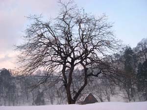
Mountains cover about 70 per cent of Japan’s land area. The Japan islands are surrounded by the sea but actually Japan is an alpine country. Our "Length of Japan" is heading for very mountain villages via the World Heritage Shirakawa-go. We hope you enjoy the top of Japan. Endless summer festival "Gujo Matsuri"
This town is famous for its pure and rich water. There are springs and canals all around the town which is also famous for its summer dancing festival, Gujo Odori. This unique dance festival has been happening for over 400 years. The dance festival continues everyday, somewhere in this town, for two months of summer - from mid July to mid September It is designated as an important component of Japan’s cultural heritage. If you are not Japanese, especially, guy or gal, young or not so young, please join the dancers – and dance with them. While dancing, forget everyday life and also forget yourself. Forget everything and express your deep feelings. You will also be in communication with Japanese village society. At this time, Japanese people also forget to be shy and become amazingly outgoing. The World Heritage:Shirakawa-go
Ride down a short distance to where R 156 meets at the intersection with R 158. Turn left, to the north (still on R 156) and this route takes you to the World Heritage, Shirakawa-go. Miboro Lake will soon appear. This is not a natural lake. It is formed by the dammed river system. Building the Miboro dam resulted in four villages and 230 houses being drowned. If you travel beside this lake late April you will see two old, and big, cherry trees in bloom. These trees had been moved from a temple which in now under the water. We say, in each cherry blossom there is a memory for those people of the four drowned villages.
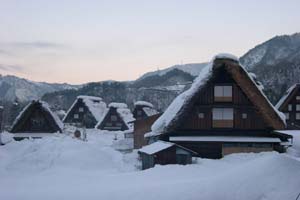
Ride down along the river (the Shoogawa) 30 km, until you arrive at groups of picturesque houses with steep thatched roofs. You have arrived at the historic villages of Shirakawa-go and Gokayama. These are World Heritage villages. You have already visited World Heritage sites on scenic byways such as the Itsukushima Shrine, Atomic Bomb Dome, Himeji Castle and historic monuments in Kyoto and Nara. All of those are in urban areas. But Shirakawa-go is within an alpine region. The style of houses with steep pitched roofs were designed for heavy winter snowfalls. The architecture, not unusual in Europe, is certainly unique in Japan. Village people are living in a difficult climatic environment. The building design enables inhabitants to be in harmony with nature – the snow simply slides off the roofs rather than destroying them. Japanese see this architecture symbolizing praying hands – symbolic of their way of living maybe? It’s a nice thought, anyway, for any Western cyclist.
Sophisticated cityscape with a history in the deep inside the forest
Many cyclists like to choose routes that involve crossing a pass. Between Shirakawago to Tokyo you'll enjoy – or might end up with a bellyful – of pass crossing. Several passes are ahead with a good climb to start with. Ride 2 km along R 360 from Shirakawago, then turn right. There is an observation point overlooking Shirakawa-go village and this is a view worth stopping for. Amou Pass is 1289 m above sea level. The road follows a stream and then ascends through a number of hairpin bends. If you plan to cross the pass after a typhoon make sure the road is open to traffic, including bicycles. It is often closed at such times owing to the possibility of mud slides. After the ascent to the summit of Amou Pass, enjoy long down hill ride to Kawai town. After passing Miyagawa river turn right and take R 471 to Furukawa town. R 471 ends at Furukawa and the road becomes R 41. Ride along the Miya river for 22 km and then you will arrive at the provincial city of Takayama. Takayama is called "Shou-Kyoto"."Shou" means small or little, or a "small Kyoto." A river runs through the center of Takayama. Temples are located on the east side and the streets are laid out neatly in a grid, similar to those in Kyoto. These days 25 million tourists visit Takayama annually. But 30 years ago Takayama was known only for its festivals held in spring and autumn. And mountaineers heading for the nearby Japan Alps used Takayama as a transfer from train to mountain bus. Through the 1970s Japan embarked on a plan for modernizing its cities and towns. This, sadly, resulted in many towns losing their traditional appearances. But Takayama was mostly spared. Mountaineers, returning home, enjoyed spending a few hours here waiting for their trains. They loved the historic amid the natural environment. And they talked about Takayama when they got home. In 1986 the Japan Government designated Takayama as a city for international tourism. Many signboards include English, encouraging foreign travelers. Please note: From Takayama to Matsumoto city there are few shops to buy food and supplies. You are going into the Japan Alps. It is best to stock up in Takayama. Route
Climate data for Shirakawauploaded:14, 04, 2019 |
|||||||||||||||||||||||||||||||||||||||


 Sekigahara also divides Japan’s landscape into two. The highest mountain in West Japan is 1982 m - Ishizuchi Mountain in Shikoku. But in East Japan where you are heading, there are so many mountains over than 2000 m, sometimes over 3000 m.
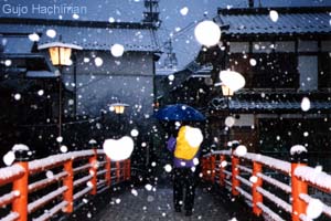 Take R 21 to Gifu City then take R 156 from Gifu city to the north. Ride up R 156 along Nagara river 50 km you will see a beautiful white castle tower in a forest town. Here is Gujo city.
 After Gujo Hachiman, ride 30 km along R156 until the road begins its winding ascent. You get to the Hirugano Highland known as a summer resort and for skiing in winter.
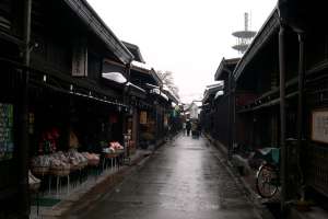 Japanese Japanese cyclists like to cross a pass in the mountains. There are so many passes in Japan and we enjoy climbing the steep roads on our bicycles. The air is fresh, views become wider, and there is less motor traffic on these roads, every pass is different, offering a new experience. Of course freewheeling down the other side into a new valley or village is wonderful.
|
|
|
Copyright "Japan Cycling Navigator". All
rights reserved.
|
